This is in no way an official Google statement.
Tons of people have been talking about Sandy Island. Is it real or is it some goof up. Why not dig in yourself? There is a lot of discussion on wikipedia. You have to look at the "Talk" page: http://en.wikipedia.org/wiki/Talk:Sandy_Island_(New_Caledonia). And I bet you can find discussion at places like the GMT mailing list and I will certainly hear from many at the AGU conference that is coming up in San Francisco next month.
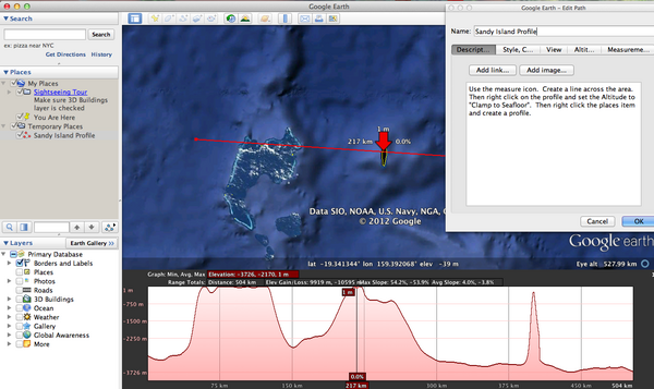
Google has put all of the LandSat imagery up on EarthEngine and you can see what we have in Google Earth and Maps. In Earth, you can make a profile of the terrain / bathymetry. You just have to make sure that you select "Clamp to Sea Floor" in your profile. Maps makers are only as good as the data they use. Google uses bathymetry from a number of sources. This is a good time for you the citizen to tell your government to support global ocean mapping and to ensure that the collected data and resulting grids are released into the public domain for all to work with. That helps to ensure that the data has a chance to be used by the likes of Smith and Sandwell and other projects that work to create global or regional bathymetry/topography datasets.
Here is the KML for a profile line over the area, but I encourage everyone to make their own profile.
SandyIslandProfile.kml
There is what it looks like:
sandy-island-google-earth.png
![Sandy Island Profile in Google Earth]()
Or install GMT and grab the latest global grid from David Sandwell's Topex site at Scripps Institution of Oceanography: http://topex.ucsd.edu/marine_topo/mar_topo.html
More sources of info:
http://blog.geogarage.com/2012/11/south-pacific-sandy-island-proven-not.html
http://googlemapsmania.blogspot.com/2012/11/the-man-responsible-for-googles-non.html
Walter Smith and Maria Seton discussing the data: Re: Sandy Island on the GMT Mailing list
Tons of people have been talking about Sandy Island. Is it real or is it some goof up. Why not dig in yourself? There is a lot of discussion on wikipedia. You have to look at the "Talk" page: http://en.wikipedia.org/wiki/Talk:Sandy_Island_(New_Caledonia). And I bet you can find discussion at places like the GMT mailing list and I will certainly hear from many at the AGU conference that is coming up in San Francisco next month.
Google has put all of the LandSat imagery up on EarthEngine and you can see what we have in Google Earth and Maps. In Earth, you can make a profile of the terrain / bathymetry. You just have to make sure that you select "Clamp to Sea Floor" in your profile. Maps makers are only as good as the data they use. Google uses bathymetry from a number of sources. This is a good time for you the citizen to tell your government to support global ocean mapping and to ensure that the collected data and resulting grids are released into the public domain for all to work with. That helps to ensure that the data has a chance to be used by the likes of Smith and Sandwell and other projects that work to create global or regional bathymetry/topography datasets.
Here is the KML for a profile line over the area, but I encourage everyone to make their own profile.
SandyIslandProfile.kml
There is what it looks like:
sandy-island-google-earth.png

Or install GMT and grab the latest global grid from David Sandwell's Topex site at Scripps Institution of Oceanography: http://topex.ucsd.edu/marine_topo/mar_topo.html
More sources of info:
http://blog.geogarage.com/2012/11/south-pacific-sandy-island-proven-not.html
http://googlemapsmania.blogspot.com/2012/11/the-man-responsible-for-googles-non.html
Walter Smith and Maria Seton discussing the data: Re: Sandy Island on the GMT Mailing list